Potent winter storm strengthening as it treks across the South, threatening extreme impacts

A potent winter storm will spread snow
By Mary Gilbert, CNN Meteorologist
(CNN) — Snow, freezing rain and rain are hitting the southern Plains Thursday as a potent winter storm strengthens and begins its trek across the South.
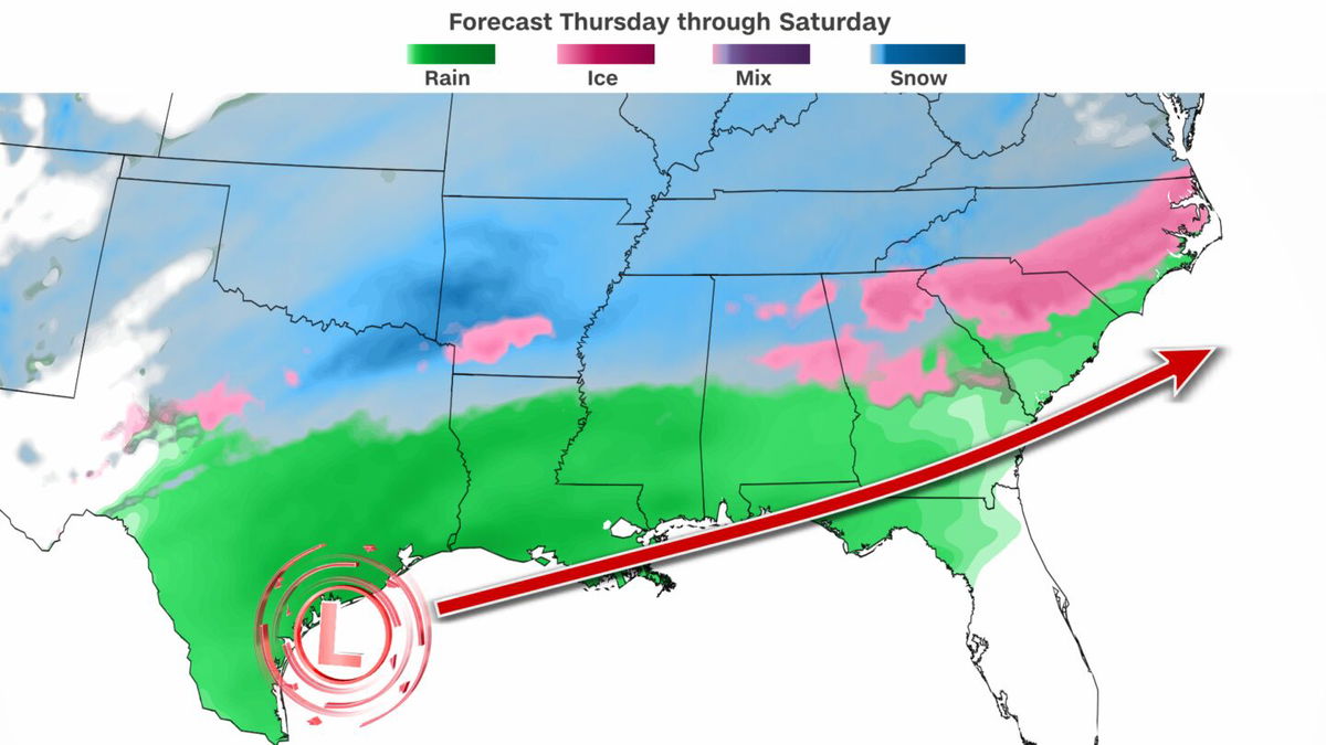
The storm’s footprint will only get more expansive as it delivers disruptive weather over a nearly 1,400 mile section of the South into the weekend amid the coldest air of the season, threatening major to extreme impacts in a region ill-adapted to winter weather.
Wintry precipitation began in portions of western and northern Texas early Thursday morning and expanded into North Texas, Oklahoma and Arkansas by the afternoon while heavy rain developed farther south.
States of emergency have been declared by governors and officials in Tennessee, Arkansas, Georgia and dozens of counties in Oklahoma and Alabama as state agencies brace for storm impacts.
Snow piled up in the morning in northern Texas and southern Oklahoma. At least 4 inches of snow had fallen by the early afternoon in an area just north of the Dallas-Ft. Worth metroplex and over the southern Oklahoma border. An inch or two of snow fell as far north as Oklahoma City.
The sloppy weather created treacherous travel with multiple reports of jackknifed tractor trailers and stuck cars in both northern Texas and southern Oklahoma. All southbound lanes of Interstate 35 in southern Oklahoma turned into a parking lot near Davis after being shut down by a crash.
It also caused problems for the major travel hub that is the Dallas-Ft. Worth International Airport. More than 2,000 flights in and out of the US had been cancelled by Tuesday afternoon with Dallas-area airports accounting for nearly 40% of those cancellations, according to FlightAware.
The Dallas Independent School District — the second-largest in Texas — announced closures of all schools and offices for Thursday and Friday due to the storm, according to its website. Schools are also closed in the nearby Plano Independent School District.
Frigid temperatures will increase power demands in Texas but grid conditions are expected to be normal, ERCOT — the operator responsible for the state’s electrical grid — said in a weather watch issued Wednesday. The state’s grid failed during 2021’s disastrous winter storm and prolonged deep freeze, resulting in the deaths of more than 200 people.
Snow, sleet and freezing rain will expand over more of the southern Plains and into the Mississippi Valley through Thursday night.
Arkansas’ Little Rock School District also closed all schools and offices Thursday and Friday. Snow will arrive in the city by the early afternoon before periods of sleet and rain mix in at night, creating treacherous travel conditions.
Any amount of ice is dangerous; just a thin layer — even a tenth of an inch — can turn paved surfaces into skating rinks, causing people to slip and vehicles to slide out of control, like what occurred over the weekend in the central US. Ice can also weigh down power lines and cause outages.
At least moderate impacts from the storm are expected in parts of Texas, Oklahoma and Arkansas given the threat for snow and ice, according to the Winter Storm Severity Index. A few areas could encounter major or even extreme impacts from this storm, meaning considerable disruptions to daily life and dangerous travel conditions are likely.
The storm will track farther east Thursday night and Friday and bring messy winter weather to much of the South. Small shifts in its track are still possible and could change snow and ice outcomes.
Snow totals will be highest from far northeast Texas and southeast Oklahoma into Tennessee and parts of the southern Appalachians. Several inches of snow could fall across this area and eclipse half a foot in spots, particularly in central Arkansas.
Northern Mississippi and far northern Alabama and Georgia could record 3 inches or more of snow from Thursday night through Friday night. Some of these areas could start as snow but change over to an icy mix as warmer air enters the area.
This will likely be the case in Atlanta, which hasn’t had at least an inch of snow in nearly seven years, but has a slight chance of it with this storm. Precipitation begins as a brief bout of snow early Friday morning but will quickly mix with sleet and freezing rain. This icy mess of precipitation will continue, with rain mixing in at times, into the overnight hours.
“Plan on hazardous travel conditions,” the National Weather Service office that services Atlanta warned Thursday, noting that travel could become difficult-to- impossible Friday into Saturday.
All city of Atlanta government offices will be closed Friday and the city has opened multiple warming centers, according to a Wednesday news release. The city also began pretreating roads on Thursday, ahead of the storm.
Precipitation will quickly expand east Friday night as the storm approaches the Atlantic Coast and a mix of snow and ice will reach the Carolinas. Charlotte, North Carolina, hasn’t recorded measurable snow — at least 0.1 inch — in nearly two years but likely will break that snow drought by this weekend.
A separate storm diving south out of Canada late Friday will work in tandem with the southern storm to pull moisture north and spread precipitation to much of the Midwest and East.
A quick round of snow totaling 1 to 3 inches or less is possible from the Midwest to the mid-Atlantic and Northeast Friday night into early Saturday morning. The storm will quickly exit the US Saturday morning, leaving gusty winds in its wake, especially in the Northeast.
CNN’s Alexandra Skores contributed to this report.
The-CNN-Wire
™ & © 2025 Cable News Network, Inc., a Warner Bros. Discovery Company. All rights reserved.