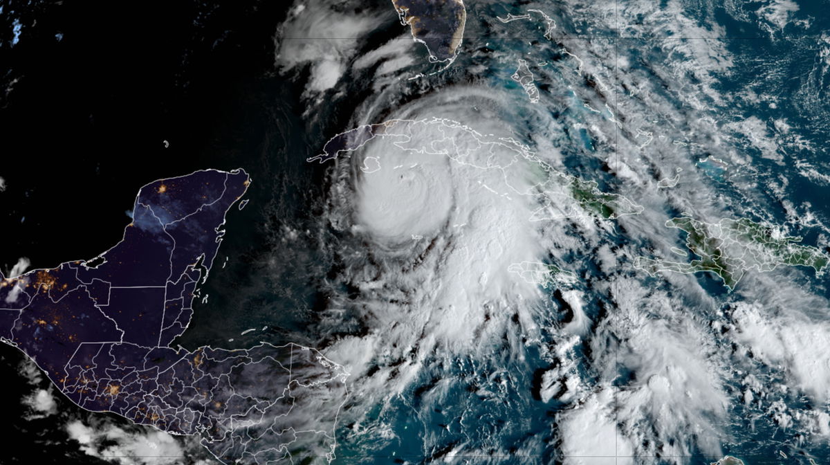
Hurricane Rafael makes landfall in Cuba as a Category 3 storm

Different forecast model solutions (colored lines) for Rafael's track are overlaid on the official forecast cone (grey) from the National Hurricane Center. The storm's uncertain track has been trending west
By Mary Gilbert, CNN Meteorologist
(CNN) — Hurricane Rafael slammed into Cuba as a Category 3 hurricane Wednesday afternoon before losing some strength as it passed over the island on its way to the Gulf of Mexico.
The powerful hurricane is the fifth major hurricane of the year in the Atlantic and the strongest this late in the year since 2020.
The storm’s winds strengthened from 60 mph to 115 mph from Tuesday afternoon to Wednesday afternoon, an increase well over the 35 mph needed for rapid intensification. As Rafael moved over Cuba, it weakened slightly to a Category 2 hurricane, with 110 mph maximum sustained winds.
Rapid intensification is happening more frequently as the atmosphere and oceans warm due to fossil fuel pollution; Rafael is the ninth storm to rapidly intensify in the Atlantic basin this year.
After it tears through the Caribbean, the hurricane is expected to face some serious resistance in the Gulf of Mexico and could make landfall as a much weaker storm this weekend anywhere from the US Gulf Coast to northeastern Mexico.
What, if any, threat Rafael poses to the Gulf Coast is still unclear but is coming into better focus, and a more confident forecast will be possible once the storm is in the Gulf on Thursday.
Rafael’s threat to Cuba is clear: It’s delivering a devastating blow as the first Category 3 hurricane to hit the country since Ian in 2022.
Heavy rain from the hurricane was spreading across Cuba and will deluge the country into Thursday. Double-digit rainfall totals are possible. Hurricane-force winds will batter the western part of the country through the evening.
Thousands of people in the western Artemisa province have been evacuated from coastal zones, officials said on state TV before landfall. Rafael’s core came ashore just east of Playa Majana in the province.
The national electric system was disconnected due to strong winds as Rafael approached the island, government officials said.
The Cuban civil defense has placed western and central provinces under a state of alarm, urging people there to limit their movement. The normally bustling streets of Havana were largely emptied on Wednesday afternoon.
While the center of the storm was about 30 miles southwest of Havana, one wind gust in the capital reached 93 mph while another at the international airport was measured at 71 mph, according to the National Hurricane Center.
This is the second blow from a hurricane in Cuba in recent weeks. Hurricane Oscar walloped Cuba in late October, killing at least seven people. The country’s power grid is also vulnerable and has collapsed multiple times, including when Oscar hit in October.
Rafael is the strongest hurricane to roam the northwestern Caribbean in November since 2009, according to data from the NOAA.
It’s forecast to become only the fifth hurricane to roam the Gulf of Mexico in November since 1966, according to hurricane expert Michael Lowry.
Rafael’s future track is uncertain
Rafael’s potential track through the Gulf of Mexico later this week and over the weekend is slowly coming into focus but is far from certain.
Rafael could still become the sixth named storm to slam into the US this season, but the areas at risk are gradually being narrowed down.
Earlier in the week, forecast models depicted very different possible paths for Rafael, but these models have started to converge on a solution. Instead of a steady track to the northwest over the Gulf and a landfall along the northern Gulf Coast, two major forecast models are more consistently showing a significant shift to the west.
The current forecast from the hurricane center indicates Rafael could potentially impact anywhere from Texas to northeastern Mexico, west of initial forecasts that had Alabama and the Florida Panhandle at risk.
“If future model runs continue to show this trend… additional leftward adjustment to the NHC track may be required,” the center said Wednesday.
Shell and BP moved some non-essential personnel off of several drilling platforms in the Gulf of Mexico ahead of Rafael’s arrival, according to news releases from both companies.
Storm-disrupting upper level winds are likely to severely deteriorate Rafael the closer the storm gets to the US coastline, regardless of where that is. Current forecasts call for Rafael to return to tropical storm status by the weekend.
Rafael’s US impacts could be limited, but the same robust tropical moisture fueling the storm Wednesday fueling torrential rainfall for the Southeast.
A widespread area of level 2 of 4 risk of flooding rainfall is in place Wednesday for parts of South Carolina, Georgia and Alabama, according to the Weather Prediction Center. Smaller portions of Georgia and South Carolina are under a level 3 of 4 risk of flooding rainfall.
Bursts of rain could cause dangerous flash flooding, but some areas could be slow to flood given how dry a lot of the soils are after a record-breaking October.
CNN’s Brandon Miller, José Álvarez, Patrick Oppmann, Michael Rios and Dave Alsup contributed to this report.
The-CNN-Wire
™ & © 2024 Cable News Network, Inc., a Warner Bros. Discovery Company. All rights reserved.