A classic El Niño winter is expected this year, forecasters say. Here’s what that means for snow and cold

By Mary Gilbert, CNN Meteorologist
(CNN) — El Niño will drive what could be a warmer or wetter winter in parts of the US this year, according to an outlook released by the National Oceanic and Atmospheric Administration on Thursday.
But don’t worry, snow lovers. El Niño – a natural ocean and weather pattern in the tropical Pacific – could also mean higher snow chances in some atypical spots and fuel more potent northeast snowstorms, forecasters say.
El Niño is forecast to be strong this winter and reach the most significant level since a very strong El Niño fostered the warmest winter on record across the US mainland during 2015-2016, according to NOAA.
While no two El Niño winters are the same, this shift typically brings wetter and cooler weather to the South while the north becomes drier and warmer.
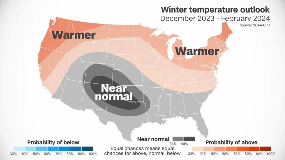
And that’s exactly what’s expected this winter. Above-average temperatures are likely across much of the northern US, according to NOAA’s outlook.
Parts of the Northwest, Great Lakes and Northeast have the highest likelihood of above-average temperatures. This will be a dramatic change for parts of the Northwest after last winter ended cooler than average for the region.
It’ll be yet another warm winter for the Great Lakes and Northeast. Last winter was one of the warmest on record for both regions, according to data from NOAA.
When forecasters predict above-average, temperatures for an entire season it doesn’t mean there won’t be any cold, just that old bouts may be less frequent and last for shorter periods of time.
Outside of an area of near-normal temperatures expected for parts of Colorado, New Mexico, Kansas and Texas, there is not a strong signal across the rest of the US, according to NOAA. Much of the southern half of the country has equal chances of being near normal, above normal or below normal.
The same cannot be said of precipitation.
A large area of the southern US from the Plains through the Southeast is expected to see above-average precipitation this winter. This precipitation could fall in the form of rain, snow or an icy mix of both.
More precipitation would be welcome news for some states that are battling intense drought, including Texas, Louisiana and Mississippi.
Southern cities like Lubbock, Texas, and Little Rock, Arkansas, average less than 8 inches of snow per year, but even these minimal snow amounts climb during an El Niño winter.
This southern precipitation pattern is one of El Niño’s winter signatures. El Niño tends to shift the jet stream south over the US. Because the jet stream is essentially a river of air that storms flow through, storms can then move across the South with increased frequency and increase the chances of precipitation.
The mid-Atlantic and far southern New England are also likely to see more precipitation than normal this winter. El Niño typically favors a less-active, west-to-east storm track across the northern US, but the Northeast will still be prone to snowy nor’easters.
During an El Niño winter, nor’easters can get “juiced up” by abundant tropical moisture and deliver “two to three big snowstorms” on average, according to Jon Gottschalck, chief of the Operational Prediction Branch of NOAA’s Climate Prediction Center.
“With the right timing, these storms can really explode off the East Coast,” Gottschalck explained.
Typically, much of the Northeast gets less snow than normal in an El Niño winter – this is true for both interior cities like Albany, New York, and coastal cities like Boston.
But this winter, a majority of the region has equal chances to record near-normal, above normal or below normal precipitation.
“There’s hope for snow lovers,” Gottschalck said.
Drier weather is likely across other sections of the northern US, which is fairly typical for an El Niño winter. NOAA’s outlook highlights the northern Rockies and Great Lakes as the places most likely to have less precipitation than average this winter.
Parts of the central and southern Rockies and the central Plains will lean wetter than average this winter.
Near- or above-normal precipitation would help drought-stricken states, including Missouri, Kansas and Nebraska. Water levels on parts of the Mississippi River have plummeted to historic low levels as a result of ongoing drought, and winter is when these levels are able to recharge.
A wet winter is also expected across much of California. The state was pummeled by many atmospheric river events in rapid succession last winter through early spring, which led the state to one of its wettest winters in history, according to data from NOAA.
The-CNN-Wire
™ & © 2023 Cable News Network, Inc., a Warner Bros. Discovery Company. All rights reserved.