Fleeing the Flames: Is Colorado Springs prepared for a major wildfire evacuation?
COLORADO SPRINGS, Colo. (KRDO) - A new fire evacuation study in Colorado Springs is raising serious concerns about just how long it will take to get people in the city's most fire-prone neighborhoods to safety if a major wildfire was to break out.
On Monday, the Colorado Springs City Council is expected to hear from an expert on the study's findings, in tandem with a proposed ordinance.
13 Investigates obtained a copy of the study conducted by disaster evacuation experts from across the country and spoke with emergency leaders and lawmakers in Colorado Springs about with it all means. Leaders with the group Westside Watch say the results from the study prove that the city is less than prepared when it comes to evacuating the community safely should Colorado Springs experience another Waldo Canyon Fire.
Emergency leaders and city officials tell 13 Investigates that despite any recent study, they are as confident as ever in their ability to get people out safely in the case of a wildfire disaster.
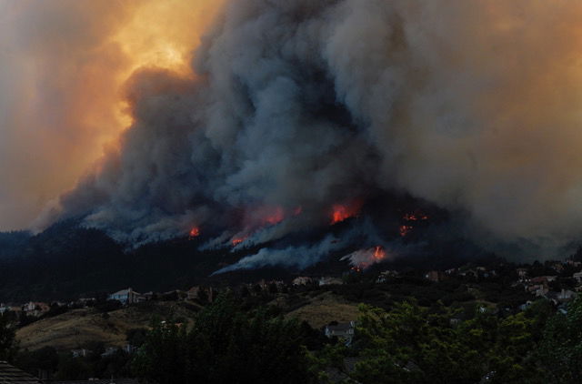
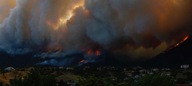
The Waldo Canyon Fire
According to the Initial After-Action Report for the Waldo Canyon Fire of 2012, on June 26, fire modeling indicated that the fire would move at an approximate rate of a quarter-mile per hour. By the end of that day, the fire would engulf more than 10,000 acres, more than half the total size of the 19-day fire.
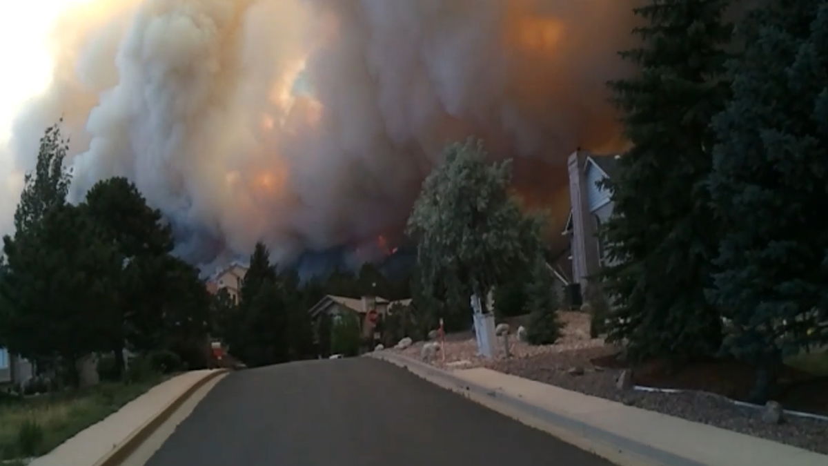
On June 26, thousands of westside Colorado Springs residents were evacuated from their homes. People who still live in these neighborhoods remember the images vividly.
“The smoke was getting thicker," said Howard Donaldson, a Mountainshadows resident since 2002. "We were genuinely terrified that we might perish if the fire kept on its course.”
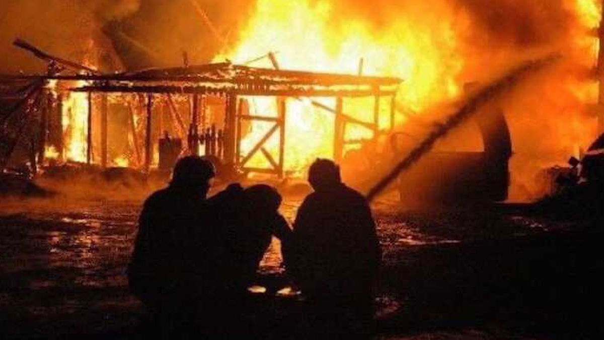
Donaldson survived, but his home didn't.
"Our home burnt to the ground. It was a total loss,” he said.
In the 19 days of the Waldo Canyon Fire, 345 homes were destroyed, and many more were damaged. Donaldson rebuilt his home on the exact same property, but the scars from Waldo persist.
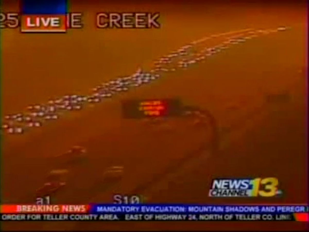
On the 26th, about three days after the fire started, 65 mph winds drove flames rapidly east and downhill directly towards homes within the city limits of Colorado Springs.
According to the after-action report, a mandatory evacuation order was issued by Mayor Steve Bach for northern Mountain Shadows/Peregrine neighborhoods. Approximately 26,000 residents evacuated their homes, while the fire rapidly moved toward the neighborhoods.
Donaldson and his wife were two of the thousands fleeing the flames that day. To him, the Waldo evacuation experience can only be described as "chaos."
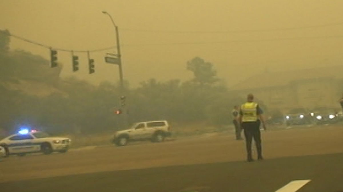
“It was so congested," said Donaldson. "It took us about 2 hours and 45 minutes to get from our home here in the mountain shadows area to our friend's home in the university heights area. That’s normally about a ten-minute drive.”
Nearly ten years later, Donaldson fears not much has been done since then to prepare for another wildfire. Especially, as the population in Colorado Springs has grown by 17% since 2010, per the U.S. Census.
“We need to be better prepared because right now we are not,” said Donaldson.
The controversial 2424 Garden of the Gods Apartment Complex would've brought in hundreds of new apartment units to the same area where the Waldo Canyon Fire forced thousands to flee. Even after the city council voted in opposition to rezoning the plot where the apartment complex was set to go, concerns over wildfire evacuations persisted.
Studying the problem
The organization Westside Watch, along with other concerned citizens, is spending thousands of dollars on studies to further understand just how prepared Colorado Springs is for wildfires west of Interstate 25.
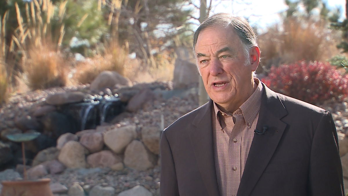
“In an evacuation, you have a massive group of people leaving at the same time. All trying to go the same direction and many of them are panicking,” said Mike Robinson, one of the evacuation experts hired to take a close look at evacuation times in Colorado Springs.
Robinson is currently a professor at Old Dominion University and has been since 2004. He studies both man-made and natural disaster emergency evacuations. According to the professor, he works in modeling disaster evacuations for regions containing hundreds of thousands of people. From hurricanes in Virginia to wildfires in California, Robinson says he has analyzed it and helped plan for it.
The group Westside Watch hired Robinson to look into how long it will take to evacuate people from their homes. Robinson tells 13 Investigates his objective was to find the Evacuation Clearance Times.
“[Evacuation Clearance Time] is the time it takes to have all the citizens in a region who are going to evacuate get out and reach a safe place," said Robinson. "It begins when they are ordered to leave, and ends when the last resident reaches a safe destination.”
Through Westside Watch, 13 Investigates obtained a copy of Robinson's findings before it is presented to Colorado Springs City Council on Monday.
Robinson researched the clearance times for two specific regions - District 1 and the 'Broadmoor' District. District 1 contains neighborhoods from the Air Force Academy all the way down to Garden of the Gods, including Mountain Shadows. While the Broadmoor District farther to the south includes the Broadmoor Bluffs, the Broadmoor Resort, and the Cheyenne Mountain Zoo.

The disaster evacuation professor used a system named FLEET (Fast Local Emergency Evacuation Times) to assess both districts' evacuation clearance times. FLEET - funded by FEMA and the Department of Homeland Security - is used to estimate evacuation times not just during fires, but for hurricanes, flash floods, even terrorist attacks.
In his presentation, Robinson says FLEET is extensively tested and provides evacuations clearance times accurate to within 15%. FLEET is not a substitute for emergency evacuation plans, it's not a replacement for regional transportation models or plans, nor is it fire or weather models.
Using FLEET, Robinson's team conducted a variety of evacuation scenarios: with and without accidents, the number of tourists, whether or not there is construction, etc.
The Findings
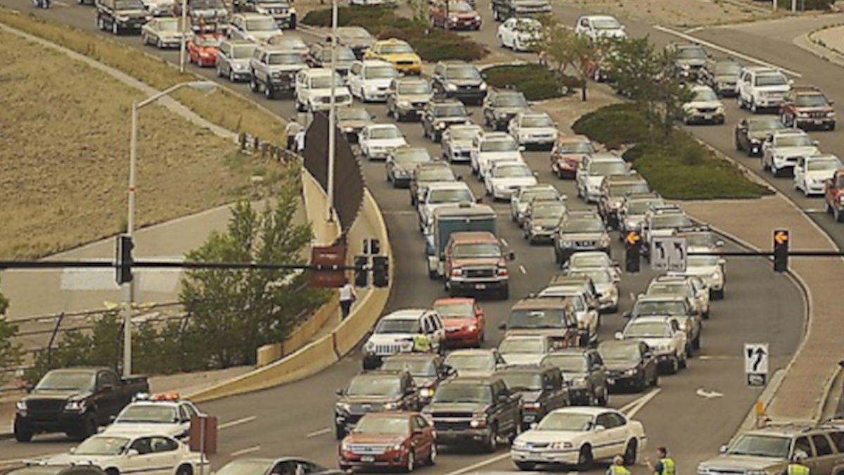
In District 1, some of the most conservative models show it would take four hours and twenty minutes to evacuate everyone resident if everyone were participating, responded within an hour, and there were 1.5 people in each vehicle. The FLEET simulations found that Garden of the Gods Road, Centennial Boulevard, Woodman Avenue, and Rockrimmon Boulevard were highly congested, and got worse the closer vehicles get to Interstate-25.
Meanwhile, in the Broadmoor District, FLEET simulations found that Cheyenne Boulevard and West Cheyenne Road were more problematic the closer vehicles got to Highway 115. The study finds that evacuees from the Broadmoor Resort, and to a lesser extent evacuees from Cheyenne Zoo, have a significant impact on the evacuation clearance times.
"If you add those people in, the time to evacuate the Broadmoor Region is greatly increased because of the number of vehicles that are added to the road," said Robinson. "It could be over five hours."
We asked Robinson if those evacuation times are acceptable.
"To ask me what the target times should be is really not a fair question. I could say I think it ought to be an hour. I'm not qualified to say that, it needs to be said by a fire expert. But if I lived on the western side of [District 1 and Broadmoor District], I wouldn't be very comfortable."
Based on his research, Robinson believes the emphasis on evacuation traffic simulations existed in Colorado Springs prior to Waldo Canyon, but not after.
Colorado Springs Leaders Respond
The professor says that when it comes to the problematic roadways that have trouble handling evacuation levels of traffic, Colorado Springs Police are actively trying to correct this.
"The law enforcement team in Colorado Springs has plans in place to place officers where needed," said Robinson.
"In the Waldo Canyon Fire, they restricted traffic from the east side of I-25 from joining the interstate in an effort to make it quicker for the evacuees to get out. I believe the police department is going to do a good job."
According to the Pikes Peak Regional Office of Emergency Management's (OEM) 2020 Evacuation Plan, during an evacuation 'control of the roadways rests primarily with the law enforcement agency having jurisdictional authority.
13 Investigates reached out to the Colorado Springs Police Department and Police Chief Vince Niski for a comment on our story and the new Westside Watch evacuation study. A spokesperson for CSPD declined our request for an interview at this time.
"The Chief will be addressing this issue with council towards the end of the month, so we are going to hold off doing any interviews until after that takes place," Lt. Jim Sokolik said in an email.
Colorado Springs Fire Chief Randy Royal says he reviewed the recent study, and he understands the concern from some living on the west side of the city. CSFD has access to FLEET, and Chief Royal says his team has used the evacuation traffic simulations.
However, Royal says 'projected' evacuation times don't factor in all the variables that go into each wildfire.
"Our only concern is the point and time. What do you do with that information based on that modeling?" asked Chief Royal. "Because it doesn’t help us in the point and time, at the point and time we have to use what is in front of us, and the conditions in front of us.”
The Fire Chief says the city's traffic & engineering team have capabilities to model traffic flow. On top of these models, Colorado Springs' first responders system possesses smaller evacuation zones. Royal says there is value in keeping zones smaller to help limit the number of people having to move out at the same time.
Robinson says if law enforcement use neighborhood fazed evacuations they could clear people in certain neighborhoods earlier - getting people further away from the immediate danger. However, fazed evacuations do not change how long it would take to get everyone out and to a safe place.
Ultimately, Royal says a smooth evacuation effort is more dependent on an informed public. The fire chief notes that having a smooth evacuation process for west side residents includes knowing the evacuation guidance from local emergency leaders, having go-bags, and understanding where to go.
13 Investigates filed a public records request for wildfire evacuation maps from the Colorado Springs Police Department. Our request was denied.
In their response, CSPD said there are no current fire evacuation route maps. However, they do possess a set of maps from 2010. Police declined to provide 13 Investigates those decade-old maps because they contain sensitive information. CSPD says the maps 'include evacuation operational details' and 'evacuation safety procedures.'
Chief Royal says he along with OEM and CSPD are confident in their ability to evacuate people from their homes in the event of a disastrous wildfire. Royal points to six people dying during four recent major wildfires in Colorado, Waldo Canyon, Black Forest, East Troublesome, and Cameron Peak. Royal says all six of those residents did not follow evacuation orders.
"We are going to pull the trigger quick, any time we need an evacuation," said Royal. "I think it comes down to personal responsibility."
On Monday, not only will the evacuation studies be presented to the city council, but Westside Watch will propose a new ordinance as well.
The ordinance would require any new development or rezones to meet a set of metrics for public safety standards to help reach the city's target evacuation times. However, Westside Watch is also calling on the City of Colorado Springs to take a deeper look at the city's current plans and roadways to see if they are prepared for evacuation traffic.
13 Investigates requested the most recent wildfire evacuation traffic study for the city of Colorado Springs. Both CSPD and OEM say they do not possess those records. But according to the Pikes Peak Area Council of Governments, the most recent study was finished back in 2010.
Through Westside Watch, 13 Investigates obtained a copy of that 2010 study, titled Colorado Springs Wildfire Evacuation Planning. The study highlights some of the exact same problems Robinson and his team are seeing today, including concerns about Rockrimmon, Centennial, and Woodmen. The study says Cheyenne Mountain Boulevard is not able to support evacuation traffic.
Colorado Springs Mayor John Suthers declined to speak with 13 Investigates. A spokesperson for the mayor said he is incapable of speaking on the issue while there is an open lawsuit pertaining to the city's decision surrounding the 2424 Garden of the Gods apartment complex.
However, in an email, the spokesperson said the mayor's office is pleased with the recent passage of Ballot Issue 2D, establishing a wildfire mitigation fund allowing the city to mitigate up to 3,000 acres in and around the city to prevent future wildfires.
As for evacuation traffic simulations and the recent FLEET study, the spokesperson for Mayor Suthers said this:
"CSFD and CSPD have access to systems that will model evacuation timelines, but it is not possible to model every situation. Emergency situations such as wildfires are dynamic events that change due to any number of non-static factors, like wind speed, weather, hazmat presence, and more. While we can consult these models for general timing, in an active event, our professional fire fighters plan and execute a response due to the real time conditions."
Mayor John Suthers' Office
Robinson says this shows a lack of understanding of FLEET or a lack of emphasis on preparation.
"Claims that the complexity of emergency evacuation conditions renders advance planning using evacuation simulations unnecessary are not uncommon," said Robinson in an emailed response to 13 Investigates. "It is true that there are many variables to be considered when forecasting wildfire behavior and it is unlikely that a wildfire will exactly match one of the scenarios for which a City plans. However, there is only one road network, and in that network there are relatively few roads suitable for carrying traffic in an evacuation. Likewise, while a fire may begin at almost any location, there are many fewer locations where a wildfire with the potential to prompt a mass evacuation could begin. Why not plan for these scenarios? Completing advance plans for the most likely scenarios is not only possible -- it is reasonable."
OEM in El Paso County holds annual evacuation drills in specific neighborhoods every year. In 2019, the drill was held for residents of the Crystal Park, Upper Skyway, and Crystal Hills neighborhoods of Colorado Springs. The 2020 drill was canceled due to COVID-19, and in 2021 the event was held in northern El Paso County.
OEM also has a 19-page evacuation plan for El Paso County. Westside Watch is calling on city and emergency leaders to conduct a more comprehensive study, and come forward with a more detailed evacuation plan before another wildfire hits.
"What I hope that is the leaders of Colorado Springs would recognize. It takes a long time to get everyone out safely longer than most of them seem to anticipate. If they are satisfied with that amount of time then they don't need to do anything. But if they are concerned then they need to conduct a complete evacuation study."
If you have a tip or lead you want our team to investigate, contact us at 13Investigates@krdo.com.
